
US Hydrological Map
$97.00
Explore America’s waterways with the US Hydrological Map. A museum-quality print charting every river and stream in stunning detail.
Discover the intricate veins of the American landscape through a scientific masterpiece that visualizes the lifeblood of the continent in stunning, artistic detail.
A Masterful Visualization of the Nation’s Interconnected Waterways
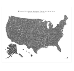
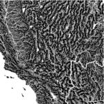
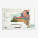
The US Hydrological Map offers a breathtaking perspective on the geography of the United States, charting every river, stream, and lake with unparalleled precision. Using the sophisticated Strahler Stream Order method, this map categorizes waterways by their hierarchy, illustrating how small headwaters merge into massive arterial rivers. The result is a striking dendritic aesthetic that resembles the branching of a tree or the complex neural pathways of the human body. Covering the Lower 48, Alaska, and Hawaii, this map allows you to trace the journey of water from its hidden mountain origins to its ultimate outflow in the sea, providing a profound understanding of the country’s intricate watersheds.
Museum-Quality Craftsmanship for the Discerning Collector
Designed to serve as both an educational tool and a sophisticated piece of fine art, the US Hydrological Map is produced with an uncompromising commitment to quality. Each piece is individually created in a specialized workshop in San Diego, printed on acid-free cotton archival paper. This premium material is specifically chosen for its longevity, rated to remain vibrant and fade-free for over 100 years. The use of high-definition inks ensures that even the most delicate non-perennial streams are rendered with crisp clarity. Whether displayed in a corporate office or a personal study, this map brings a professional and intellectual atmosphere to any space it inhabits.
Product Specifications for US Hydrological Map
This archival-grade cartographic print is defined by the following technical details:
-
Dimensions: 24” (W) x 30″ (H).
-
Material: OBA- and acid-free cotton archival paper.
-
Printing: High-definition premium inks for intricate detail.
-
Classification: Hydrological Map / Archival Fine Art Print.
-
Features: Includes the Lower 48, Alaska, and Hawaii; unframed.
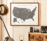
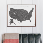
How to Display and Preserve Your US Hydrological Map
The US Hydrological Map is delivered unframed, providing you the flexibility to select a frame that complements your interior design. To ensure the 100-year longevity of the archival paper, it is recommended to frame the map behind UV-protective glass and hang it away from direct, prolonged sunlight. Because of the incredible detail, placing it at eye level allows viewers to truly appreciate the fine linework and hierarchical stream orders. This map is a premier Gift for All Occasions, particularly for environmental scientists, outdoor enthusiasts, or anyone with a passion for American geography.
What is the Strahler Stream Order method?
This is a mathematical method used by hydrologists to rank the size and hierarchy of streams. On this map, it allows you to visually distinguish between small creeks and major rivers through varying line weights and detail.
Is the map printed on standard poster paper?
No, it is printed on museum-quality, acid-free cotton archival paper, which is significantly thicker and more durable than standard paper, designed to last a century without yellowing.
Does this map include seasonal or temporary streams?
Yes, the map is highly detailed and includes non-perennial waterways, giving a complete picture of the landscape’s hydrological potential even in drier seasons.
How do I handle returns if there is an issue?
Since this product is individually created and shipped directly from the vendor, we cannot accept standard returns. However, if your map arrives with any issues, please contact robert kline for immediate assistance.
About the Maker: Muir Way
The US Hydrological Map is a flagship creation by Muir Way, a studio dedicated to the intersection of rigorous data and beautiful design. At robert kline, we pride ourselves on partnering with makers who transform raw geographic data into evocative works of art. Muir Way’s process involves deep research into historical and modern topographical records to ensure every line on the map is accurate. Our mission is to provide professional-grade decor that tells a story of the natural world, fostering a deeper connection between our customers and the land they call home.
Celebrate the natural rhythm of the land with a map that captures the hidden flow of the American spirit. Transform your wall into a gateway of geographic discovery. Purchase your US Hydrological Map today and own a timeless tribute to the power and beauty of water.
| Dimensions | 28 × 20 × 7 in |
|---|

Related products