
New York 1973 3D Raised Relief Map
$183.00
Explore the Empire State with the New York 1973 3D Raised Relief Map. A tactile, historical map featuring unique raised topography.
Rediscover the Empire State through a captivating blend of historical cartography and modern tactile technology that brings the rugged beauty of the Northeast to life.
A Tactile Exploration of New York’s Diverse Topography
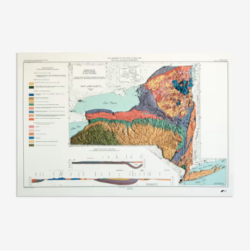
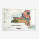
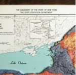
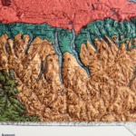
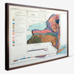
The New York 1973 3D Raised Relief Map is a masterful transformation of a vintage 1973 document into a three-dimensional landscape. Created in a specialized workshop in San Diego, this map begins with a high-resolution scan of historical records which are then meticulously synchronized with modern elevation data. Through a precise process of heating and vacuum-forming, the map is molded to physically represent the state’s iconic landforms. From the towering peaks of the Adirondack Mountains to the gentle slopes of the Hudson Valley and the sandy expanses of Long Island, this map allows you to visually and physically trace the geological history of the region, offering a sensory experience that standard flat maps simply cannot replicate.
Professional Grade Cartographic Decor for the Modern Home
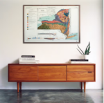
Designed for historians, educators, and design enthusiasts alike, the New York 1973 3D Raised Relief Map serves as both a high-impact conversation piece and a sophisticated educational tool. The map features detailed landform legends and a geological timeline, providing deep context into the forces that shaped the state’s terrain over millennia. Printed with vibrant colors and mounted on a sturdy mat board, this unframed piece offers a professional aesthetic suitable for any office, library, or study. It represents a unique marriage of mid-century charm and contemporary manufacturing, making it a standout addition to any collection of high-quality geographic art.
Product Specifications for New York 1973 3D Raised Relief Map
This precision-engineered map features the following technical details:
-
Dimensions: 36” (W) x 24” (H).
-
Material: Durable plastic vacuum-formed over a precision mold, mounted on a mat board.
-
Features: Includes landform legends and geological timeline data.
-
Classification: 3D Raised Relief Map / Historical Geography Decor.
-
Origin: Individually handcrafted in San Diego, CA.
How to Use and Care for Your 3D Relief Map
The New York 1973 3D Raised Relief Map is intended for wall display or tabletop study. Because the map is vacuum-formed over ridged elevations, it is best viewed at eye level to appreciate the depth of the terrain. To maintain the map’s condition, occasionally dust the surface with a soft, dry cloth. Due to the unique 3D printing process on plastic, some fine text may appear slightly warped by the terrain—this is a hallmark of the raised relief medium and adds to its authentic, tactile nature. This piece makes a remarkable Gift for All Occasions, particularly for native New Yorkers or those with a passion for American history.
Why is some of the text on the plastic map different from a paper map?
The vacuum-forming process stretches the material over the ridges of the mountains. This means that while the topography is accurate, some of the smallest text may appear less sharp or slightly warped compared to a flat paper print.
Is the map ready to hang upon arrival?
The map comes mounted on a mat board but is unframed. This allows you the professional flexibility to choose a frame that best suits your specific interior design and workspace.
Can I return the map if I change my mind?
Because each map is individually created and shipped directly from the vendor, we are unable to accept standard returns or exchanges. If your product arrives with any issues, please contact the team at robert kline for assistance.
Does this map show modern city developments?
No, this map is based on historical 1973 data. It is designed to capture the geographical and political state of New York as it existed in the early 70s, providing a nostalgic and historical perspective.
About the Maker: Muir Way
The New York 1973 3D Raised Relief Map is produced by Muir Way, a studio that prides itself on combining rigorous scientific data with artistic flair. At robert kline, we choose to feature Muir Way because of their dedication to local manufacturing and historical accuracy. By utilizing modern elevation data to enhance vintage maps, they create “living” history that you can touch. Our mission is to provide professional-grade, insightful decor that connects people to the places they love through quality craftsmanship and innovative design.
Elevate your space with a map that honors the grandeur of the New York landscape. Own a piece of history that invites discovery with every touch. Purchase your New York 1973 3D Raised Relief Map today and bring the peaks and valleys of the Empire State into your home.
| Dimensions | 36 × 28 × 8 in |
|---|

Related products