
Hawaii Islands 1971 3D Raised Relief Map
$168.00
Explore the Aloha State with the Hawaii Islands 1971 3D Raised Relief Map. A tactile, historical map featuring vibrant topography.
Experience the majestic peaks and deep oceanic trenches of the Aloha State through a sophisticated blend of vintage cartography and cutting-edge tactile technology.
A Tactile Journey Through Mid-Century Hawaiian Topography
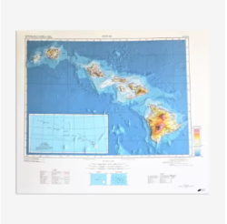
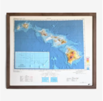
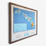
The Hawaii Islands 1971 3D Raised Relief Map is a masterwork of geographic art that transforms a flat historical document into a living three-dimensional landscape. Crafted with precision in San Diego, this piece begins with the scanning of original 1971 records, which are then meticulously aligned with modern elevation data. Through a complex process of vacuum-forming and heating, the high-quality plastic is molded to mirror the true ridges, volcanic craters, and valleys of the islands. This map provides a unique sensory experience, allowing you to trace the rugged terrain from the Big Island to Kauai with your fingertips, covering both land elevations and the fascinating bathymetry of the surrounding Pacific floor.
Professional Craftsmanship for the Modern Explorer
Designed for collectors, historians, and interior design enthusiasts, the Hawaii Islands 1971 3D Raised Relief Map serves as a high-impact educational and decorative tool. Unlike traditional flat prints, the raised relief format offers a deeper understanding of the geological forces that shaped the islands. Each map is individually produced to ensure the colorful details of the 1971 aesthetic remain vibrant. Mounted on a sturdy mat board, this unframed piece is ready to be showcased in an office, library, or living room, offering a professional-grade look that celebrates both mid-century style and the diverse environmental beauty of Hawaii.
Product Specifications for Hawaii Islands 1971 3D Raised Relief Map
This detailed cartographic model is manufactured with the following technical specifications:
-
Dimensions: 26” (L) x 22” (H).
-
Material: Durable plastic vacuum-formed over a precision mold and mounted on a high-quality mat board.
-
Classification: 3D Raised Relief Map / Historical Scientific Decor.
-
Features: Includes terrestrial topography and underwater bathymetry.
-
Origin: Individually made in San Diego, California.
How to Display and Care for Your Raised Relief Map
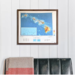
The Hawaii Islands 1971 3D Raised Relief Map arrives unframed, allowing you to choose a custom frame that matches your decor or mount it directly for a more tactile experience. To maintain the integrity of the raised features, avoid placing heavy objects against the surface. Because the map is printed on plastic to allow for the molding process, the fine print is a unique characteristic of the medium—simply dust the surface with a soft, dry microfiber cloth to keep the colors sharp. This makes for a truly unforgettable Gift for All Occasions, especially for those with a deep connection to the islands.
Why is the text on the map slightly different from paper prints?
Since this is printed on plastic and vacuum-formed over ridges, very small text may appear warped or slightly less sharp than on flat paper. This is a natural result of the 3D process that gives the map its unique physical texture.
Does this map show the ocean floor?
Yes, one of the standout features of this 1971 edition is the inclusion of bathymetry, allowing you to explore the underwater topography surrounding the Hawaiian chain.
Is the map framed upon delivery?
The map is shipped unframed and mounted on a mat board. This provides a professional base while giving you the flexibility to select a frame that suits your personal style.
How do I handle shipping or product issues?
As this product ships directly from the vendor, we cannot accept standard returns. However, if you encounter any issues with your order, please reach out to our support team at robert kline for assistance.
About the Maker: Muir Way
The Hawaii Islands 1971 3D Raised Relief Map is produced by Muir Way, a studio dedicated to the intersection of history and geography. At robert kline, we are proud to feature makers who prioritize technical accuracy and artisanal quality. By combining historical documents with modern elevation modeling, Muir Way creates pieces that are not just maps, but gateways to understanding the earth’s surface. Our mission is to provide professional-grade, insightful decor that inspires a sense of wonder and appreciation for the natural world.
Bring the spirit of the islands into your home with a piece that bridges the gap between history and modern design. Discover the peaks and valleys of Hawaii like never before. Purchase your Hawaii Islands 1971 3D Raised Relief Map today and own a tangible piece of volcanic history.
| Dimensions | 30 × 36 × 8 in |
|---|

Related products